BLOG

Research Vessel in Penobscot Bay November 2-7, 2023

Please be advised that R/V Endeavor, a research ship homeported at the University of Rhode Island, will be in Penobscot Bay November 2-7 conducting research. The 180-foot vessel will be sampling the Bay at specific stations (shown in red on the map below) for mercury contamination in the water column and in zooplankton. Each station will run 1-3 hours. The vessel will operate 24 hours each day but may remain at a station at night. The ship’s call sign is WCE5063, operating on channel 16 and 13; captain's email is [email protected]. Vessel web page is https://marineops.gso.uri.edu.

2023 Fall Trawl Survey

Notice to Harvesters: Maine-New Hampshire Inshore Trawl Survey to Begin September 25 

Maine Department of Marine Resources sent this bulletin at 09/15/2023 02:58 PM EDT

Read More

Fishermen Encouraged to Watch Out for Bright Orange SAILDRONES in Eastern Gulf of Maine Beginning August 28, 2023

From NOAA Fisheries via NEFMC

Saildrone Gulf of Maine Mapping Project Announcement (click for charts and coordinates)

Fishermen who work in the eastern Gulf of Maine will want to be on the lookout for two wind-propelled surface vehicles that will be operating in the area from August 28 through October 18, 2023. These vehicles, called SAILDRONE VOYAGERs, are bright orange.

Read More

Manomet Blue Crab Survey

DMR Announces the Following

This message has been sent on behalf of Manomet.

Read More

Wells Harbor Dredge: Public Comments Sought Part 2

Notice to Lobstermen: Proposed Wells Harbor Dredge, Comments Due 7/25/23

DMR Solicits Public Comment Regarding the Maintenance Dredging of the Wells Harbor Town Anchorages

Pursuant to 38 M.R.S. §480-D, sub-§9, the Maine Department of Marine Resources (DMR) is required to provide the Maine Department of Environmental Protection with an assessment on the impacts on the fishing industry of a proposed dredging operation. The Town of Wells is proposing maintenance dredging of two town anchorage areas within Wells Harbor to be conducted concurrently with US Army Corps of Engineers Federal Navigation Project maintenance dredging. The work consists of dredging of the town anchorage areas to a depth of 6 feet MLLW with allowance for up to 1 foot of overdredge to 7 feet MLLW. The proposed dredging entails removing approximately 19,800 cubic yards (cy) of sandy material from a total of 3.3 acres. A cutterhead pipeline dredge will remove the material and pump it to areas on Wells Beach for beach nourishment. Dredging work is proposed to be performed between November 9 and March 31. The timing for the town dredge will depend on the contractor’s schedule for the already approved federal project scheduled to take place between September 15 and March 31. Periodic maintenance dredging of the anchorages will occur every one to four years to maintain the majority of their authorized depths. The federal and town interim dredges may or may not occur together. If completed together, the dredging timeline, method, and beneficial reuse would be coordinated with the federal activities. If undertaken separately, it is likely that the town dredges will be done by a bucket dredge, with the effort focusing on the excessively shoaled areas in the anchorages. Placement will occur at the nearshore site off Wells Beach.

Written comments about this dredging project must be received by DMR at the email or mailing address listed below by 5:00 p.m. July 25, 2023Department of Marine Resources, Attn: Environmental Permit Review, 21 State House Station, Augusta, Maine 04333

Read More

DMR Simplied Explanation of Addendum XVII

From Patrick Keliher, re: update on Addendum Twenty Seven

Since I issued the update on Addendum XXVII, I’ve learned that there is still some confusion around the timing of changes, so here is a simplified explanation for LMA1 harvesters.

NOTE: Every October the ASMFC Lobster Management Board (Board) will review trawl and ventless trap survey results to see if the 35% decline in the recruit abundance has occurred.  We are currently at a 23% decline in abundance, and at this point we can’t predict when the 35% decline will be reached. 

Read More

Southwest Harbor Dredge Spring 2023 - UPDATED


Please be advised that Prock Marine Company will be dredging the Dysarts Great Harbor Marina in Southwest Harbor. Work will be starting on February 21th through March 31th 2023 Operations will be conducted daily from 0700 to 1700.

Read More

Public Comment on Scarborough River Federal Navigation Project

Pursuant to 38 M.R.S. 480-D, sub-9, the Maine Department of Marine Resources (DMR) is required to provide the Maine Department of Environmental Protection with an assessment on the impacts on the fishing industry of a proposed dredging operation. The U.S. Army Corps of Engineers, New England District is proposing to dredge an area of approximately 22 acres from shoaled areas in the 8-foot entrance and 6-foot main channels and the 6-foot anchorage of the Scarborough River Federal Navigation Project. This is expected to produce a volume of approximately 130,000 cubic yards (cy) of predominantly sandy material. The project is expected to occur in two phases. The first phase is an immediate priority for safe navigation in the 8-foot entrance channel. The first phase area will be removed by a government-owned hopper dredge between April 1, 2022 and May 31, 2022 (approximately 30,000 cy). The second phase of the dredge project would remove the remaining material (approximately 100,000 cy) by a hydraulic cutterhead over a one-to-three-month time-frame, between November 1 and March 15 of the year(s) in which funds become available. This material will be pumped onto Western Beach, Scarborough.

DMR will accept written comments about the potential impacts of the proposed dredging operation on fishing in the area to be dredged and impacts to the fishing industry of the proposed transport route of the dredge spoils to the Little River near shore placement area. Comments should be sent to DMR at the email or mailing address listed below by 5:00 p.m. April 1, 2022.

Read More

Piscataqua River Dredge

Great Lakes Dock and Dredge, Inc. will be conducting maintenance and improvement dredging in Portsmouth Harbor and Piscataqua River, Newington, New Hampshire and Eliot, Maine starting 1 November 2021 to 1 April 2023. 

Operations will be conducted 24 hours a day, 7 days a week, and transiting the dredged material south to Nantasket Beach as well as to the Isle of Shoals North disposal site.  The attached haul route shows the width of the approved route.  Fishermen should remove gear from the haul route immediately.  Maine DMR works with the US Army Corps of Engineers (USACE) to provide notice to fishermen of these routes, but did not receive final confirmation of this route until today.  According to the USACE, dredging will begin on or about Nov 16th – the initial material SHOULD be going to MA nearshore sites BUT there is a possibility they may have some material would need to go to IOSN.  Blasting will begin in December, with all of that material going to IOSN. 

Read More

Health Insurance Marketplace

Open Enrollment for 2022 coverage ended on January 15. You may still be eligible to enroll in 
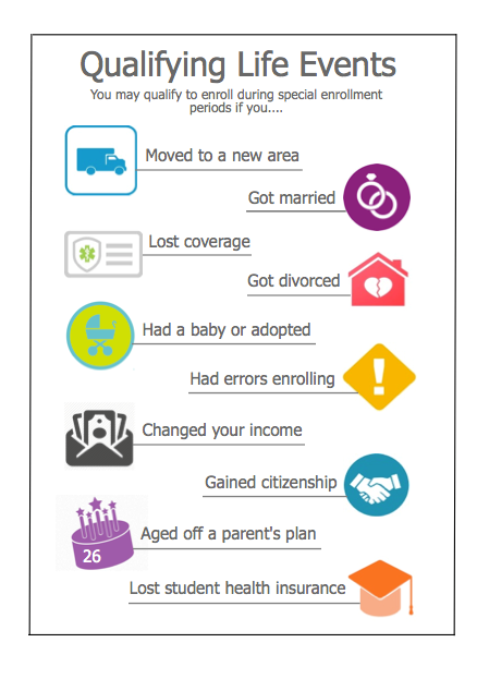
coverage outside of the annual Open Enrollment period if you have a qualifying life event -- like losing the insurance you get through your job, getting married or divorced, or having a baby. These events would qualify you for a Special Enrollment Period (SEP). If you qualify for MaineCare, you can apply any time through My Maine Connection.


Read More

Lobster with Yellow bands

2021 & 2022:GMWSRS (Grand Manan Whale & Seabird Research Station), phone # (506-662-3804) is conducting a berried lobster tagging project that will be carried out fall/winter in LFA 38. Each tag has GMWSRS contact info and a unique number, one for each lobster. They are interested in knowing where lobstermen might see these females.

We are continuing to deploy yellow ziptie tags, each with a unique number. This year the tags say “GMWSRS TXT 910-232-9567”   If you see a tagged lobster, please text her with the tag number and location of capture at that cell number. The easiest way is to take a snapshot of the tag number (see photo right) and one of your plotter, and text those to Heather’s phone. You can also call the research station landline at 506-662-3804, or email Heather at [email protected].

Read More

Female Lobster Thermal Preference Study

We are going to attach small temperature loggers to some females. WE NEED TO GET THESE TAGS BACK TO GET THE DATA, so if you see one of these grey thermal tags, please remove it from the lobster and text Heather at 910-232-9567, and we will figure out how to get the tag from you.

Phone: 506-662-3804  Email: [email protected]

The grey TidbiT attached to the lobster can store up to 96,000 measurements and their information can be downloaded via bluetooth.

Lobster with Red Tags

If you catch a lobster tagged with a red T-bar marked “DMC” (pictured), please report details below to Everett Rzeszowski at UMaine by texting/ calling (207) 588-1759 or emailing [email protected].
Red Tagged Lobster_
What to report? Date, location, tag #, length, sex, egg status, v-notch status, cull status. Photographs of tag.
When? If you catch a lobster with a red T-bar “DMC” tag.
How? All information required can be reported by texting or calling (207) 588-1759. Photographs can be sent to (207) 588-1759 or[email protected].
Why? UMaine Darling Marine Center has partnered with Monhegan Island lobstermen to estimate lobster population in the Monhegan Island Lobster Conservation Area through a tagging study. 
Can you keep a tagged lobster? Yes. You can keep a tagged legal lobster. If you report keeping the lobster you will receive a raffle entry.